


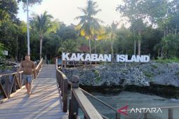
Samarinda, Kaltim (ANTARA) – The East Kalimantan Provincial government is strengthening marine spatial management by installing boundary markers in the Coastal and Small Island Conservation Area (KKP3K) of the Derawan Islands and surrounding waters in Berau to advance world-class marine tourism.
“We installed boundary markers and information boards in this area to strengthen ecosystem protection while simultaneously supporting sustainable marine tourism activities,” said Head of the East Kalimantan Marine Affairs and Fisheries Service, Irhan Hukmaidy, in Samarinda on Friday.
He explained that the regulations governing the use of the conservation area were designed to ensure biodiversity preservation is maintained amidst the rapid growth of nature tourism visitors.
Based on the Decree of the Minister of Marine Affairs and Fisheries Number 87 of 2016, the total area of the conservation zone in Berau’s waters spans 285,548.95 hectares.
To facilitate spatial use for local fishing communities and tourism operators, the government has divided this marine expanse into three zoning systems managed collaboratively.
A “limited utilization zone” covering 53,441.62 hectares has been allocated specifically to facilitate smooth fishing activities and sustainable marine tourism operations.
Leading regional tourism destinations, such as Kakaban Island, Sangalaki Island, and the Kaniungan Besar and Kaniungan Kecil islands, are located within the limited utilization zone.
Meanwhile, the government has also established a “core zone” covering 10,011.52 hectares, designated as an area of absolute protection for conservation targets, free from any form of exploitation.
The conservation waters serve as a vital natural habitat for the survival of rare species that act as major tourism draws for Berau, including green sea turtles, whale sharks, manta rays, and stingless jellyfish.
They consider the establishment of boundary markers crucial so that visitors, tourism operators, and local fishermen can distinguish between areas open to visitation and those requiring absolute protection.
“To support compliance with the spatial zoning regulations, the local government continues its outreach efforts—ranging from public awareness campaigns and brochure distribution to direct assistance for coastal community groups,” Hukmaidy said.
The East Kalimantan Marine and Fisheries Service is also strengthening partnerships with non-governmental organizations (NGOs), corporations, relevant authorities, and universities to foster a participatory marine conservation ecosystem.
“These conservation boundaries help ensure the sustainability of Berau District’s tourism sector, allowing for continued economic growth without compromising the region’s rich underwater ecology for the future,” he said.
Related news: East Kalimantan opens legal clinic for 506 indigenous communities
Translator: Ahmad Rifandi, Cindy Frishanti Octavia
Editor: Bayu Prasetyo
Copyright © ANTARA 2026