


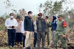
Jakarta (ANTARA) – The National Disaster Mitigation Agency (BNPB) is continuing massive and integrated efforts to combat forest and land fires across six priority provinces as dry conditions peak.
The agency is deploying weather modification operations, ground and aerial firefighting, and strict law enforcement to suppress fires in South Sumatra, Jambi, Riau, West Kalimantan, Central Kalimantan, and South Kalimantan.
“BMKG predicted a strong El Niño in 2026, and that has indeed proven true, with burned areas expanding across provinces where peatlands are a priority,” BNPB Head Suharyanto said in a written statement received on Saturday.
According to Suharyanto, weather modification operations have proven the most effective of the three firefighting methods, as the resulting rainfall can cover vast areas.
Ground firefighting operations rank second in effectiveness, particularly in peatlands, where underground fires are difficult to extinguish. Water bombing ranks third due to the limited payload capacity of around four tons per sortie.
“However, these three methods are inseparable. Water bombing knocks down the fire front, allowing ground crews to step in and douse the terrain. Without water bombing, ground forces face extreme risks,” he added.
Suharyanto emphasized that peatland fires require specialized handling. While surface flames may appear to have been extinguished, embers can continue to smolder deep underground.
To address this, the agency uses peat injection nozzles to pump water 1 to 2 meters deep into the soil.
He added that among the three affected provinces in Kalimantan, South Kalimantan has experienced relatively milder fire impacts.
The BNPB head also stressed directives from the president and vice president to maximize weather modification operations whenever rain clouds show even the slightest potential to produce rainfall.
These directives also apply to areas across Kalimantan and Sumatra that are currently free of fires.
He cited Banjarmasin as an example, noting that although there were no active fires in the city, cloud seeding was carried out after the Meteorology, Climatology, and Geophysics Agency (BMKG) identified potential rain clouds to protect the city from drifting smoke from various neighboring districts.
Nationally, BNPB data as of September 8, 2026, shows that the estimated total area of burned land across the six priority provinces had reached 76,922.3 hectares.
Of the 72,009.10 hectares of burned peatland recorded through September 6, 2026, 939.45 hectares remained under intensive firefighting efforts.
Related news: Gibran apologizes as toxic haze from land fires persists in Kalimantan
Related news: Japanese aircraft conduct test flights to combat forest fires: BNPB
Related news: VP calls for intensified patrols to prevent wildfires through 2027
Translator: Hana Dewi, Raka Adji
Editor: M Razi Rahman
Copyright © ANTARA 2026