


Jakarta (ANTARA) – Minister of Public Works (PU) Dody Hanggodo has instructed an identification of the impact of the cold lahar flood from Mount Semeru in Lumajang Regency, East Java.
“The Ministry of Public Works is committed to addressing the impact of the disaster by deploying all available resources. The safety and recovery of affected residents are our top priorities,” Dody said in a statement in Jakarta on Wednesday.
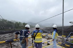
The ministry, through the Disaster Management Task Force of the Brantas River Basin Agency (BBWS Brantas), is identifying and inventorying the impact of the cold volcanic mudflow in Lumajang. The effort aims to determine the condition of affected water resources infrastructure and prepare for further response needs.
Initial findings show that several water resources facilities were affected by volcanic mudflow material. These include a concrete flood and lahar control embankment buried under volcanic material (VDRRSL S4 KD 3 project), as well as three sabo dams and a riverbank embankment below a suspension bridge that suffered scouring.
As an initial step, Head of BBWS Brantas Muhammad Noor said the task force has evacuated project personnel and equipment from the affected sites.
“BBWS Brantas has also placed flood-control materials and heavy equipment on standby to support emergency response once conditions on the ground are declared safe,” Muhammad Noor said.
The ministry, through BBWS Brantas, is also conducting monitoring and coordinating with the Regional Disaster Management Agency (BPBD) and the Mount Semeru Volcano Observation Post. The coordination is intended to obtain updates on volcanic activity, weather conditions, and potential increases in river discharge, so that response measures can be adjusted to current field conditions.
BBWS Brantas also carried out a review and assessment of the Regoyo River, part of the Rejali Watershed in the Bondoyudo-Bedadung River Region, in Sumberwuluh Village, Candipuro District.
Although water levels in the Regoyo River have receded, the potential for increased discharge remains a concern given the continued high rainfall around Mount Semeru. In view of this, physical emergency response work cannot yet be carried out because conditions at the site remain hazardous.
Further inventory work is ongoing to determine the extent of damage and the response required at each location. BBWS Brantas will promptly mobilize heavy equipment, along with emergency response personnel and materials, once conditions are declared safe.
Based on recommendations from the Indonesia’s Center for Volcanology and Geological Hazard Mitigation (PVMBG), Mount Semeru’s activity is at Level III (Alert). The public is prohibited from any activity in the southeast sector along the Besuk Kobokan River, up to 13 kilometers from the summit.
Beyond that radius, the public is also asked to stay at least 500 meters from the riverbanks along Besuk Kobokan, as the area could be affected by the expansion of pyroclastic clouds and lahar flows.
The cold lahar flood occurred after heavy rain fell over the summit, slopes, and surrounding river areas of Mount Semeru on Monday (2/11), between approximately 00.14 and 05.32 WIB.
According to a BBWS Brantas report, rainfall reached 134.6 mm in the observation period from 00.00 to 06.30 WIB. The conditions caused a surge in river discharge carrying volcanic material with an estimated material size of 25–65 mm.
Related news: Mount Semeru erupts, spewing ash 1,000 meters above summit
Related news: Police battle wildfire on Mount Semeru in East Java
Translator: Suharsana Aji S, Fauzul Azhim Bin Fakhrurazi
Editor: Primayanti
Copyright © ANTARA 2026